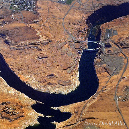
Glen Canyon Dam and Lake Powell | ©2013 David Allio
Presented from more than five miles above, the Glen Canyon Dam was constructed 50 years ago in the Glen Canyon on the Colorado Plateau near Page, Arizona. The retained waters of the Colorado River, fed from Utah by Mill Creek, Green River, San Rafael River, Dirty Devil River, Escalante River, and the San Juan River form Lake Powell and discharge into the Grand Canyon.
Lake Powell is the second-largest reservoir in the nation when filled to maximum capacity. Currently, the water level is over 100 below the capacity level first achieved in 1980, 17 years following the completion of dam construction.
"Beneath the still waters of artificial lakes, created by dammed rivers across the West, rest indigenous ruins, thousands of petroglyphs, barbed wire fences, churches, old ranch houses, railroad tracks, even outmoded dams – and people’s lives." – attributed to Stanley Crawford[1].
[1]Lippard, Lucy R. The Lure of the Local: Place in a Multicentered Society. New York: New Press, 1997. Print.
Additional References:
U.S. Department of the Interior. “CRSP Glen Canyon Unit Home Page – Reclamation, Upper Colorado Region.” CRSP Glen Canyon Unit – Upper Colorado Region. U.S. Department of the Interior, 25 Nov. 2008. Web. 23 Nov. 2013.
Buchanan, Mark, and Paul Hirt. “Glen Canyon Dam.” NCHGC: Sites and Stories: Colorado River Corridor: Glen Canyon Dam. Arizona State University, 20 July 2010. Web. 23 Nov. 2013.
Camera: Nikon D3 | Lens: AF-S Nikkor 24-70mm f/2.8G ED | Focal Length: 70mm | Exposure: f/8 – 1/2000th – ISO 500
Protect valuable camera equipment during travel with a Think Tank camera bag.
You must be logged in to post a comment.